EsriUC2019 Best Mentions
The Esri User Conference in San Diego is over and, after a few days of random Oceanography and Unexpected Seals, I’ve been back for a day now. Still, there are a couple of mentions I need to make before I wrap up my notes on the summit and go back to work on the upcoming stuff. […]
The Esri User Conference in San Diego is over and, after a few days of random Oceanography and Unexpected Seals, I’ve been back for a day now. Still, there are a couple of mentions I need to make before I wrap up my notes on the summit and go back to work on the upcoming stuff.
1. The Plenary Session
Videos are now online and you can take advantage of them to see what I mean when I say that the city of Pasadena rocks. It’s this video, in case you want to skip.
Other notable mentions I fell in love with were:
- the NatureServe system for biodiversity with their Map of Biodiversity Importance for 2,500 species at risk in the continental U.S. (video here);
- the City of Zwolle and their data-driven struggle with climate change when you have a Country that’s mostly below sea level (video here);
- the parcel editing function of ArcGIS Pro 2.4, and of course I would be interested in that (video here);
- the Metropolitan Transportation Authority of New York City and the way they use the Virtual Train Track System in order to use GIS and BIM for real-time management of their linear infrastructure (video here);
- Exxon Mobile usage of the ArcGIS Indoors App (video here): their showcase was quite enthralling, although I later discovered that you integrate BIM and ArcGIS Indoor by… tagging rooms and exporting everything to CAD so, nice proof of concept but the technology is not here yet;
- the amazing speech delivered by ambassador Stefano Toscano on behalf of the Geneva International Centre for Humanitarian Demining and the work they’re doing in on land mines (video here): talking about using technology to be really significant, is enough to give everyone pause and to have ourselves ask to ourselves “What the fuck is that we’re doing?”;
- the Lurgan School from Northern Ireland and the incredible work they’re doing on integration and safety with their students (video here): an amazing project;
- African Parks and their fight to poachers through the collection and analysis of spatial data (video here).
2. Insights for ArcGIS Data: Best Demo. Ever.
My first notable mention of a session actually involves something that happened on Friday morning.
Now, if you’re familiar with the Conference, nothing happens on Friday morning: it’s the day after the party and Esri is sensible enough not to schedule User Cases Presentations in the morning after the party (Autodesk, I’m talking to you): you’ve got a bunch of demos at 9.30 am, the closing keynote at 10.30 and then you can go back nursing your hangover. If you wake up at all.
I must say I was tempted to stay in bed.
Boy, was I glad I didn’t?
What I attended was a technical demo of a thing I didn’t get a chance to see throughout the conference: Insights for ArcGIS.
And I don’t have many pictures because I confessed I was completely captivated by the long and structured demo they delivered. Surely the best demo of the Conference. Possibly the best demo I have seen in a while and that must have taken a while to prepare as well. And I’m not praising them just because they were giving away dragon stickers. Honest.
You have a couple of tips and tricks on-line: I’ll just post one, for you to understand what is it about.
3. Best Case Study of the Conference. And it’s us.
Another beautiful surprise came from another conference I originally attended mostly out of courtesy and patriotism, and to show my support to a fellow countrywoman. I’m talking about Marcella Faraone from Italferr, the second Italian enrolled in the conference.
It’s not that I don’t find railways interesting (I do, a great deal) it’s just that I thought to myself “Hey, they’re from here, I can see them at home”. Good thing I didn’t listen to that voice, which has been proven to be wrong before, as this was probably the best Case Study of the entire conference. The panel they were inserted in, was:
Leveraging Location Intelligence in Rail
The other user case actually didn’t show up so the session I’m talking about really is:
Integrated ArcGIS and BIM for the entire Infrastructure Lifecycle Management
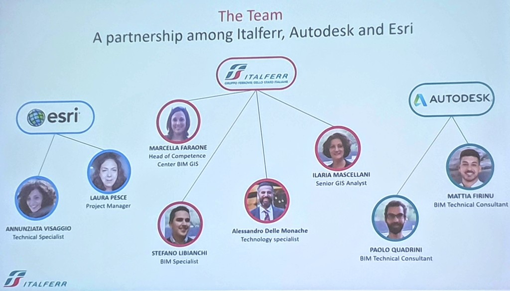
Marcella Faraone – Italferr
Their opening statement was obvious, but something we don’t hear often enough and obviously one of my main thoughts for this sabbatical year I’ve been taking (one of the main thoughts I can share, at least): we hear a lot about the advantages of BIM and maybe we finally made it when it comes to vertical construction, but when it comes to linear infrastructure the advantages of BIM are not so obvious and not so well documented.
Their Competence Center for BIM and GIS (a sub-division of the Information Technology Department, under the Strategy and Innovation Officer) has been working around that for a while: the only high-quality video I have of their work is one uploaded by Esri Italia, about a different case study, but gives you a clear idea of the amount of work these guys put in their proofs of concept.
The case study presented in San Diego was on a different project: the Brescia Tramway and they’ve been working on it in partnership with both Autodesk and Esri and I was really proud to see one of my students up there, Mattia Firinu, alongside with renowned expert, Dynamo guru Paolo Quadrini, that I’m proud to call my colleague on other projects.

The workflow showcased was a complex system integrating the Esri GIS platform and our BIM authoring tools, with Infraworks and Navisworks on one side, Revit and Dynamo with Civil 3d on another, and BIM360 Docs gluing everything together (any reference to previous collaboration platforms: unintended). If you have ever been out of your Revit shell, you can start to feel the data-integration pain flowing in you just by looking at this slide. But in seeing their work portrayed, you get why they were referenced as excellence also in other lectures. To put it in the words of one of Esri’s representatives in a lecture specifically on GIS and BIM integrations, “Italians just went ahead and did it”. Indeed. No fuss, no complaining: just competence and hard work.
For the Brescia Tramway, these were basically the steps:
- GIS was used as an analysis tool, supporting decision making;
- the Concept design of the railway itself was done in Civil 3d;
- Infraworks was used to check on the concept;
- Detailed design was done in Revit, with support geometry from Civil 3d linked through Dynamo (on those things Civil is better at… or I might say on those things Revit still sucks at);
- Navisworks manage was involved for 3d coordination;
- in the Preconstruction phase, ArcGIS Pro came back into the picture for 4d analysis such as the flow of traffic and network analysis;
- a proof of concept around Asset Management was done in ArcGIS pro, publishing data in ArcGIS on-line and linking everything with BIM360 Docs (and, why not, with some augmented reality thrown in for good measure).
For their work, they’ve been awarded the Special Achievements in GIS price, this year, and there isn’t much I can add to that, if not that I was so very proud of being able to say:
“That’s my Country, I know these guys”.


One Comment