Spatial, non spatial and numerical: our way towards computational thinking
San Diego, 08.07.2019. Esri UC One of the main issues you hear about teaching BIM, especially to high school and university students that might still have some neuroplasticity about them, is how to get them to think computationally. The first things I learned, during my first day of attendance here at the Education Summit at […]
San Diego, 08.07.2019. Esri UC
One of the main issues you hear about teaching BIM, especially to high school and university students that might still have some neuroplasticity about them, is how to get them to think computationally.
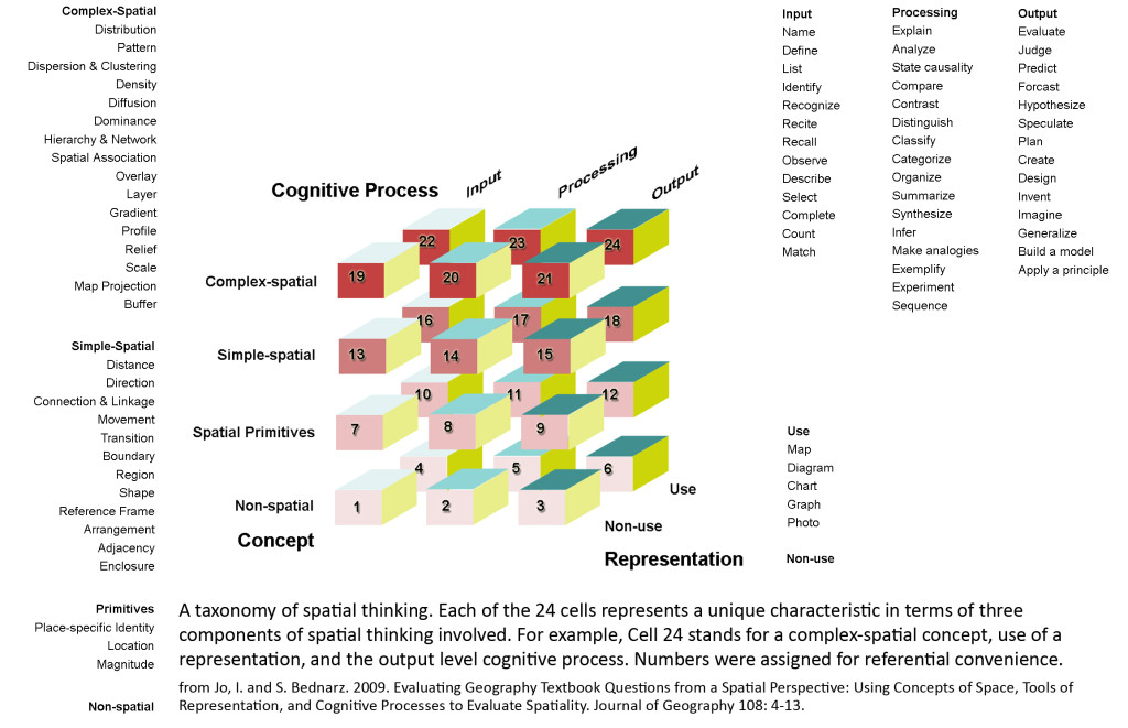
The first things I learned, during my first day of attendance here at the Education Summit at the Esri User Conference in San Diego, is that the GIS guys have a similar issue: how to get students to think spatially.
Bob Kolvoord from James Madison University gave a very interesting flash talk this morning, showcasing some data on how attending GIS classes jogged his students’ brains, prompting them to use spatial parts of their brains to approach non-spatial problems as well during their deductive reasoning.
If you’re not familiar with spatial vs non-spatial reasoning, here’s an example of a spatial problem:
The pen is on the Table. + The Cat is under the table. = The Pen is above the Cat.
Besides this being basic English, you can’t solve this unless you have a vague notion of above and below.
On the other hand, a strictly non-spatial problem would be:
Cats live longer than Dogs, + Turtles live longer than Cats. = Turtles live longer than Dogs.
Besides from this being technically inaccurate (it depends on the breed, or so I’m told), this doesn’t have anything to do with where the cat is: he simply cannot escape death.

Now, as you might see, there’s also a spatial way to approach the non-spatial issue: if you’re visualizing one element with a visual bar for the life span, for instance, this is what you’re doing.
What was particularly interesting in professor Kolvoord’s speech this morning, was how he surveyed a change in how the students thought before attending a GIS semester in approaching non-spatial problems, and how their problem-solving attitude changed afterwards. The study showed them using more and more parts of their brains involved with spatial thinking, even when approaching non-spatial problems.

As you might imagine, this triggered me into thinking about if and how this problem is relevant for us. And then a thought hit me: we actually have the reverse problem. Our students are visual by nature and they are heavily trained, almost brainwashed, into approaching everything from a spatial point of view. If the problem with GIS is overlaying data to a spatial way of thinking, our issue is to bring back a way of thinking that deconstructs space and geometry into the basic alphanumerical data that constitute it.
One of my favourite cartoons in childhood, that probably influenced me a lot, was Donald in Mathmagic Land. I recommended it during my first experiment of on-demand focus days at the Masterkeen course, alongside fiction books such as Flatland, and essays such as the brilliant Euclid’s Window and the delightful String, Straight-Edge and Shadow.
While Flatland was a fairly popular choice, even too much of a popular choice which prompted me to bring it down as an option, the others weren’t. These choices might be back with a vengeance on September 3rd when I’ll open dances at MK8. I might add something for a more numerical focus, like some Buckminster Fuller stuff, and may God help us all.
To achieve the kind of thinking, along with numerical cognition we might need to trigger something that prompts people to think in terms of parameters, which is basically the ultimate problem-solving attitude: the attitude of solving problems before they even arise.

Along the same line, I observed something interesting in an early afternoon session specifically titled Geography Education and Computational Thinking. Although the first part of the session was a frankly mediocre attempt for a discussion among attendees, rather than a lecture, what I found to be interesting was the general approach. The main questions were:
- how and if was the main topic being taught in schools (their main topic being geography);
- how and if was computer science being taught in the very same schools;
- if and how GIS could be a bridge between the two topics and maybe help the latter, in clear ascension, support the first that is declining.
The argument here was that computer sciences by themselves are not enough and you need spatial thinking to support the data and algorithms that computer sciences are supposed to mine and elaborate.
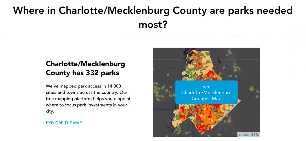
In the second and much more interesting part of the session, the speaker showed the example of an analysis about Charlotte that can be found on the Trust for Public Land Website.

What basically happens is that the Parkserve website is recommending, based on data that are not contextualized from a geographical point of view, an investment on public parks in a wealthy area that already has lots of private parks. You need someone trained in geography and sociology to figure that data out and maybe tweak the algorithm. This is nor new for us: Yuval Noah Harari is helping us understand that we need a historian to figure out digital transformation as well.
What got me thinking, here, was the general approach from two points of view: a general one and one specifically worrying for us.
1. Are we training digital scribes?
When we talk about computer sciences, we seem to be treating it as if it was writing in ancient Egypt: a skill within itself, with no connection to what you are actually coding about, that allows you to ascend to a superior social class (people who will actually have a job).

Fast forward to real life.
If I were to tell you that I’m a writer, your first question would be something along the line of “What do you write about?”.
Even if I were to tell you that I am a calligrapher you would need more details. And I happen to know one first hand from my Tolkien days.
Computer sciences are basically the writing of our digital age and we won’t get out of this tangle until we understand that everybody needs to have basic training in them, since elementary school: not everyone will become a writer or a calligrapher, but everyone will be able to code up a shopping list. That would be a grand achievement.

2. What is our goal?
On a more general note, I loved how the discussion was directed towards creating a link between geography and computer sciences using GIS.
Having the very same discussion in our field would be fairly easy: how to create a link between architectural design, engineering or fabrication/construction and the very same computer sciences using BIM. Instead, the discussion we’re having is on how to teach BIM per se, if not just the authoring tools. As if the damn thing was a goal in itself, rather than a set of tools to achieve what are supposed to be the actual goals.
One of the main reasons for this might be the “digital scribe” attitude of even some of our best trainers and their lack in having a personal specialization beyond BIM (so if you only know the digital tools, all you are going to talk about are the digital tools themselves and they will quickly become the ultimate goal, giving that they are the only thing giving you a job right now). And while this might be necessary for this transition period when lots of people need to be specialized very quickly, I don’t think it’s a strategy we can find to be sustainable in the upcoming future.
Scenario number one. We need to go back being designers, builders and project managers specialized in the digital tools, in order to train professionals that are not digital scribes. There will still be writers and calligraphers, virtuous specialized professionals of the digital age, but we need basic training for everybody and here’s only a limited actual need for computational superheroes. Most of today’s superheroes are forced to be superheroes just because of everybody else’s digital ineptitude.
Scenario number two. Digital tools are becoming more and more intuitive on the end-user side and nobody needs to be a mechanic anymore in order to drive a car, therefore we will keep having a larger and larger gap, with dumb users hitting on their keyboard with a club and some digital specialists actually transforming those digital doodles into something that will actually get built.
Pick the future you want.

3. Are we hungry enough?
On a side note, what I picked up as a general vibe was also a rather interesting feeling to compare to us.
Geography is dying. It’s not being taught in schools anymore (the British guys were worried about it almost ten years ago) and professionals are trying to save it and promote a renewed, more relevant version of it.
Our problem might be similar, giving the tremendous amount of crisis we’ve bee undergoing in the AEC Industry, but for some reasons, we don’t seem to be hungry enough. We don’t have the clear notion that our industry is dying because, fundamentally being a primary sector, we have the arrogance of thinking that we are essential and people will be homeless without us. But is this really the case?
I’ll leave you with that. It’s five o’clock. I’m going to have a beer by the swimming pool.


One Comment